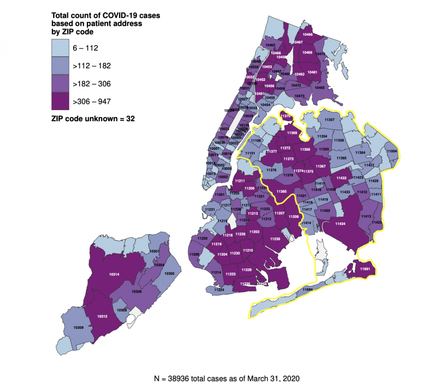
Queens is highlighted in yellow (NYC Department of Health)
April 2, 2020 By Allie Griffin
Corona, the Queens neighborhood that shares the same name as the horrid virus, has the most COVID-19 cases in New York City — with nearly 1,000 cases in its zip code, according to newly released data.
Elmhurst has the second greatest number of cases and Jackson Heights is high on the list of neighborhoods as well.
The new data released by the NYC Department of Health yesterday confirms multiple anecdotes that Jackson Heights, Elmhurst and Corona are the neighborhoods at the epicenter of the coronavirus pandemic.
Hundreds of people who live in the neighborhoods — represented by zip codes in the data set — surrounding the heavily burdened Elmhurst Hospital have contracted the virus.
As of March 31, 947 residents of Corona (11368), 831 residents of Elmhurst (11373) and 492 residents of Jackson Heights (11372) have contracted COVID-19.
The Department of Health provided the numbers from March 31 when the city’s total cases was at 38,936 — those numbers have since swollen to 45,707 yesterday afternoon.
The higher number of cases may be tied to poverty. Many lower income areas have a higher number of coronavirus cases. In Corona, about 20 percent of residents live below the poverty level.
The Rockaway Peninsula, also in Queens, illustrates this trend.
Far Rockaway — where 21.4 percent of the population lives below the poverty line — has 436 COVID-19 cases. Conversely, Breezy Point, on the western portion of the Rockways— where just 3.1 percent of the population lives below the poverty line — has only 25 confirmed cases.
Dr. Mitchell Katz, the CEO of the City’s public Health + Hospitals network, was unable to pinpoint exactly why the numbers were high in the Elmhurst-Corona areas at a press briefing in city hall yesterday afternoon. However, he noted that many people who reside in Queens’ poorer neighborhoods live in cramped quarters where multiple people share space making it easier for the virus to spread.
“We know that in Queens, many families — because of poverty — live together in very close quarters, so that while we’re practicing as a city social distancing, you may have multiple families living together in a very small apartment,” Katz said. “So it’s easy to understand why there’s a lot of transmission of COVID occurring.”
Corona’s average household size is 3.9 people — about 1.4 times the average household size across the city — according to Census data, however that number is likely underreported.
The Department of Health (DOH) released the raw data yesterday after reporters repeatedly asked the mayor and his administration to disclose the number of cases per neighborhood as other places like Nassau County and Los Angeles have done.
The mayor first released a map Friday that failed to provide any meaningful data. It merely showed the percentage of those tested who came back positive by hospital zone. Earlier this week he then released an updated map that took the same data, but by zip code.
The DOH released a new map yesterday along with the raw data. However, neither detailed the number of COVID-19 deaths per zip code or neighborhood.
The City’s map (above) has four brackets with a different color code provided based on the number of cases. The ranges are wide — making it difficult to get an idea of what neighborhoods have been the most hard hit without reviewing the actual data.
For example, the first bracket range is 6 to 112 cases — a 106 point range, the second bracket range is 112 to 182 cases — a 70 point range, the third bracket range is 182 to 306 cases — a 124 point range, and the last bracket is 306 to 947 cases — a whopping 641 point range.
The above Queens Post interactive map details the exact number of COVID-19 cases in each zip code. It also illustrates that the outer boroughs have seen larger numbers of coronavirus cases than Manhattan.
Queens, which is on the forefront of the pandemic with the most coronavirus cases and resulting deaths (15,217 cases and 447 deaths as of 4:30 p.m. yesterday), has several zip codes where hundreds have contracted the novel coronavirus.
Other Queens neighborhoods with high numbers include Ridgewood/Glendale with 425 cases, Forest Hills with 418 cases, Jamaica Hills and Jamaica Estates with 405 cases.
Woodside, East Elmhurst, Rego Park, Kew Gardens and Springfield Gardens each have more than 300 confirmed cases of coronavirus as well, according to the data.
Dr. Katz said the large numbers in Queens and the lack of hospitals in the borough has led to Elmhurst Hospital being overburdened.
“Queens has about half the number of hospital beds per thousand persons than Manhattan and especially where Elmhurst is,” Katz said at the press briefing.
Queens has the fewest hospital beds per capita in New York City, despite being the second-most populated borough with 2.3 million residents. It has just 1.66 beds per 1,000 residents, according to a February report by the Queens Borough President.
Katz said that the influx of coronavirus patients at Elmhurst Hospital in the past 10 days has led to significant changes. The hospital went from 29 ICU beds 10 days ago — to 111 ICU beds today.
In 2009, Jackson Heights and Elmhurst lost two now-desperately needed hospitals, according to Council Member Daniel Dromm.
“We lost two hospitals in 2009 in my Council district alone before I was elected,” Dromm wrote on Twitter. “St. John’s and the old Jackson Heights Hospital. Hospital consolidation forces many to go to Manhattan.”
One Comment

Great article!
One criticism: you misplaced East Elmhurst (zip code: 11370). Here is a link to an image from Google Maps that shows the correct placement of zip code 11370: East Elmhurst, NY 11370 https://imgur.com/gallery/ZJP3eXU